Synopsis:
The upcoming weekend looks decent for January as high pressure moves in. More clouds than sun is expected today, with more sun than clouds on Sunday. Yep, you guessed it readings will be above average, by a couple degrees anyway. The average high is in the upper 30s.
A weak disturbance will move through Sunday night with the possibility of snow showers.
Any clouds and early flakes Monday should give way to partly sunny skies. Readings will still be tolerable.
High pressure will dominate on Tuesday and Wednesday bringing with it abundant sunshine and still above average readings.
The deep cold air will not make it down into our area as long as the polar jet stream remains in Canada. The pacific jet stream continue to scream. These are contributing factors to a snowless Winter, so far…
Stay tuned.
Keep it here for a no hype, no nonsense forecast.
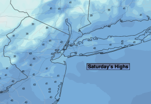
Saturday:
Clouds, some sun. Highs in the mid 40s. Northwest winds at 8-15mph.
Tonight:
Mostly clear. Lows around freezing in the City, the 20s inland. Northwest winds at 5-10mph.
Sunday:
Sun to clouds. Highs around 40º.
Monday:
A few morning flakes, otherwise clouds giving way to sun. Highs in the lower to mid 40s.
Tuesday:
Sunny. Highs in the mid to upper 40s.
Wednesday:
Sunny. Highs in the lower to mid 40s.