Synopsis:
A weak low just East of our region will strengthen slightly as it moves off the New England coast. Scattered showers are likely today. There will be long periods of dry times. The cooldown will continue.
The upcoming weekend looks decent still for January as high pressure moves in. Yep, you guessed it readings will be above average, by a couple degrees anyway.
A weak disturbance will move through Sunday night with the possibility of snow showers.
Any clouds Monday should give way to partly sunny skies. Readings will still be tolerable.
High pressure will dominate on Tuesday bringing with it abundant sunshine and still above average readings.
The deep cold air will not make it down into our area as long as the polar jet stream remains in Canada.
Stay tuned.
Keep it here for a no hype, no nonsense forecast.
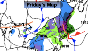
Friday:
Scattered showers. Cooler. Highs in the mid 40s. Northwest winds at 5-10mph.
Tonight:
Becoming partly cloudy. Lows in the mid 30s in the City, around freezing inland. Northwest winds at 5-10mph.
Saturday:
Sun and clouds. Highs in the mid 40s.
Sunday:
Sun to clouds. Highs around 40º.
Monday:
Clouds to sun. Highs in the lower to mid 40s.
Tuesday:
Sunny. Highs in the upper 40s.