Synopsis:
The last weekend of November will be a 50/50 Split. Today will feature sunshine and our continuation of mild temperatures as high pressure moves into the Mid-Atlantic States. It’ll be a winner!
The subtropical jet will have a developing area of low pressure coming out of the Southern Plains into the Upper Ohio Valley on Sunday. The day looks to start off with some limited sun but clouds will thicken rapidly and rain will develop during the afternoon. No cold air will be available for wintry precipitation.
Our continuation of above average temperatures will continue into next week with high pressure once again moving in from the West for Monday and Tuesday. The sun will rule the sky.
A cold front will approach on Wednesday with showers likely during the afternoon. It’ll be warm ahead of the approaching system.
Enjoy our mild temperatures while we can.
Stay tuned.
Keep it here for a no hype, no nonsense forecast.
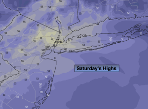
Saturday:
Sunny. Mild. Highs in the mid 50s. Northwest to West winds at 8-12mph.
Tonight:
Mostly clear. Lows in the mid 40s along the urban corridor, the 20s & 30s inland. West to Southwest winds at 5mph.
Sunday:
Becoming mostly cloudy. Rain developing by midday. Mild. Highs in the mid 50s.
Monday:
Partly sunny. Highs in the mid 50s.
Tuesday:
Sunny. Seasonable. Highs around 50º.
Wednesday:
Mostly cloudy. Warm. Showers likely during the afternoon. Highs around 60º.