Synopsis:
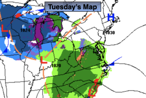
Low pressure will form over the Southeast and move up the coast tonight and Wednesday morning. Morning sun will give way to increasing and thickening clouds today. Rain will likely develop by dark. Highs will be about ten degrees below the average highs of the mid 50s.
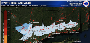
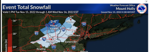
There will be enough cold air well North and West for the potential of a Wintry mix tonight. Not much in the way of accumulation is expected with the exception of the Poconos and Catskills where a few inches of snow and sleet may fall (maps above). Elsewhere, rain is expected.
Early morning rain will give way to sunshine on Wednesday. It’ll be cool.
Sunshine will dominate on Thursday through Saturday as unseasonably cold air funnels in from Canada courtesy of high pressure. Saturday looks to be the coldest day of the season so far.
We are stuck in this cold pattern for quite some time, possibly as long as just before Thanksgiving.
Stay tuned.
Keep it here for a no hype, no nonsense forecast.
Tuesday:
Sun to clouds. Rain possible by dark. Highs in the mid 40s. Northeast winds at 5-10mph.
Tonight:
Rain. A mix of wet snow , sleet and rain well North and West. Lows in the lower 40s in the City. The 30s inland. Northeast winds at 10-20mph.
Wednesday:
Morning rain to sun. Highs around 50º.
Thursday:
Mostly sunny. Highs in the mid 40s.
Friday:
Mostly sunny. Highs in the mid 40s.
Saturday:
Mostly sunny. Highs around 40º.