Synopsis:
Many suburbs experienced their first frost or freeze this Wednesday morning with lows in the 20s and lower 30s.
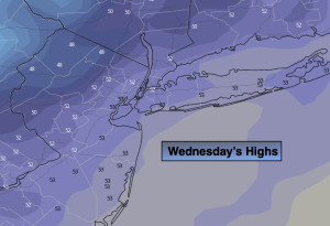
Today will be crisp with plenty of sunshine as a West wind blows around an upper level low over Southern Canada. Temperatures will be well below average. Today will be the coolest day of the season far. Readings will be close to ten degrees below average. The average high is in the mid 60s.
Tonight won’t be nearly as cold as last night with temperatures bottoming out near freezing well inland.
On Thursday the core of the coolest air will move out of the region. It’ll still be cool and mainly sunny.
High pressure will move build over the Southeast and East on Friday into Saturday. This will result in more seasonable temperatures under a bright sky. Saturday looks to be spectacular.
On Sunday, Atlantic low pressure will most likely affect the region with clouds and the possibility of afternoon showers.
Stay tuned.
Keep it here for a no hype, no nonsense forecast.
Wednesday:
Mostly sunny. Highs in the mid 50s. West to Southwest winds at 10-20mph.
Tonight:
Clear and chilly. Lows in the mid 40s in the City, the 30s elsewhere. West winds at 5mph or less.
Thursday:
Mostly sunny. Highs in the upper 50s.
Friday:
Sunny. Highs in the lower 60s.
Saturday:
Sunny. Mild Highs in the mid to upper 60s.
Sunday:
Sun to clouds. Threat of afternoon showers. Highs in the mid 60s,