Synopsis:
Today through Thursday will be crisp with plenty of sunshine as a Northwest wind blows around an upper level low over the Great Lakes and Southern Canada. Temperatures will be well below average as our first shot of unseasonably cool Canadian air moves in. Readings will be close to ten degrees below average. The average high is in the mid 60s.
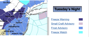
Frost and Freeze Warnings have been posted for tonight as many readings inland will be near that critical 32º mark. Bring in any potted plants or they maybe wilted by Wednesday morning.
High pressure will move build over the Southeast and East on Friday into Saturday. This will result in more seasonable temperatures under a bright sky.
Keep it here for a no hype, no nonsense forecast.
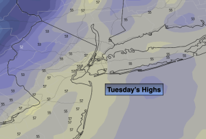
Tuesday:
Mostly sunny, breezy and cooler. Highs in the mid 50s. West to Northwest winds at 8-12mph.
Tonight:
Clear and cold. Lows in the lower 40s in the City, the 30s elsewhere with scattered frost in the Northwest ‘burbs. West winds at 5mph or less.
Wednesday:
Mostly sunny. Highs in the mid 50s.
Thursday:
Mostly sunny. Highs in the mid 50s.
Friday:
Sunny. Highs in the lower 60s.
Saturday:
Sunny. More seasonable. Highs in the mid 60s,