Synopsis:
Wow! What a difference a day makes. The Fall chill has arrived for this first full day of Autumn. Unseasonably cool Canadian high pressure is moving in and responsible for our dramatic change. Today will feature a mix of sun and clouds with a brisk wind. It’ll feel every bit like Autumn with readings remaining in the lower 60s, the upper 50s inland! The average high is 74º.
Tonight will be the coolest night since last Spring. A few 30º readings are likely inland. Grab that blanket!
The first weekend of Fall will start off delightful as high pressure sits overhead. A bright Saturday is expected with readings a few degrees below average. Sunday will feature more clouds and the possibility of afternoon showers as a disturbance works in from the West.
The beginning of the workweek looks delightful with seasonable readings.
Keep it here for a no hype, no nonsense forecast.
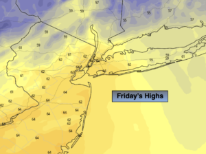
Friday:
Partly sunny, breezy and much cooler. Highs in the lower 60s, the upper 50s inland. Northwest winds at 15-25mph with higher gusts.
Tonight:
Clear and much cooler with diminishing winds. Lows in the upper 40s in the City, the 30s and 40s inland. Northwest winds at 15-25mph and diminishing.
Saturday:
Sunny. Highs in the around 70º.
Sunday:
More clouds than sun. Scattered afternoon showers. Highs in the lower 70s.
Monday:
Mostly sunny. Highs in the mid 70s.
Tuesday:
Partly sunny. Highs in the mid 70s.