Synopsis:
It will feel every bit like Summer this last few days of the season. Monday through Wednesday will be warm as high pressure remains over the region. Abundant sunshine is expected. There’s a chance of showers this evening as a weak disturbance moves through.
Thursday is Fall’s debut and right on que a significant cool front will move through the region with scattered showers. Readings will be near the seasonable average of 75º. By Friday the front will have moved offshore and allow for chilly high pressure to work in from Canada. It will every bit like Autumn with readings remaining in the 60s.
Keep it here for a no hype, no nonsense forecast.
Monday:
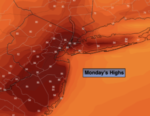
Partly sunny. Warm. Chance of evening showers. Highs in the mid to upper 80s. Southwest winds at 8-15mph.
Tonight:
Scattered early showers, otherwise partly cloudy. Lows in the 60s in the City, the upper 50s inland. West to Northwest winds at 5mph.
Tuesday:
Sunny. Highs in the lower 80s.
Wednesday:
Sunny. Warm. Highs in the lower to mid 80s.
Thursday:
Scattered morning showers, otherwise partly sunny. More seasonable. Highs in the mid 70s.
Friday:
Partly sunny, breezy and much cooler. Highs in the mid 60s.
Catch me Saturday on the Fox Business Network from 6am-9am and on the Fox Weather Stream until 10am. Find us on Tubi, Roku TV and YouTube TV and as always the Fox Weather App. It’s Free!