Synopsis:
Our string of fine September days will continue for the last weekend of Summer. High pressure will dominate the Northeast. Abundant sunshine (there maybe some early clouds) with comfortable temperatures are expected for Saturday. Average highs are in the mid to upper 70s. Readings maybe a few degrees below average with a wind off the water (especially at the coast). Temperatures will get back above average by the Sunday as the winds blow from the Southwest around the area of high pressure.
It will feel every bit like Summer Monday through Wednesday. The only chance of any showers are late Monday as a weak disturbance moves through.
A bright, warm Tuesday and Wednesday is anticipated as high pressure builds to our South. Wednesday is Summer’s finale-Fall arrives Thursday.
Enjoy!
Keep it here for a no hype, no nonsense forecast.
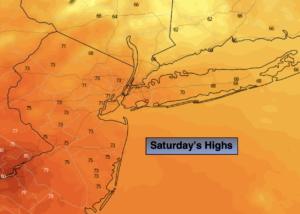
Saturday:
Mostly sunny. Comfortable. Highs in the lower to mid 70s in the City. Cooler at the immediate coast and over Long Island. Northeast to Southeast winds at 5-10mph.
Tonight:
Clear. Lows in the mid 60s in the City, the 50s in the ‘burbs. South to Southwest winds at 5mph.
Sunday:
Sunny, warmer. Highs in the mid to upper 80s.
Monday:
Partly sunny. Warm. Chance of late day showers. Highs in the mid to upper 80s.
Tuesday:
Sunny. Warm. Highs in the lower to mid 80s.
Wednesday:
Sunny. Warm. Highs in the lower to mid 80s.
Catch me Saturday on the Fox Business Network from 6am-9am and on the Fox Weather Stream until 10am. Find us on Tubi, Roku TV and YouTube TV and as always the Fox Weather App. It’s Free!