Synopsis:
Our string of fine September days will continue. High pressure will move in and dominate the Northeast through the weekend. Abundant sunshine and seasonable temperatures are expected today and Saturday. Average highs are in the mid to upper 70s. Temperatures will get back above average by the Sunday as the winds blow from the Southwest around the area of high pressure. It will feel every bit like Summer both Sunday and Monday. Scattered showers are possible Monday afternoon with an approaching weakening cool front.
A bright, warm Tuesday is anticipated as high pressure builds to our South.
Enjoy!
Keep it here for a no hype, no nonsense forecast.
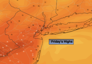
Friday:
Sunny. Highs in the mid 70s. Northwest winds at 5-10mph.
Tonight:
Clear. Cool. Lows in the lower 60s in the City, the upper 40s & 50s in the ‘burbs. Northeast winds at 5mph.
Saturday:
Sunny. Highs in the upper 70s.
Sunday:
Sunny, warmer. Highs in the mid to upper 80s.
Monday:
Partly sunny. Warm. Chance of afternoon scattered showers. Highs in the mid 80s.
Tuesday:
Mostly sunny. Warm. Highs in the mid 80s.
Catch me Friday on the Fox Weather Stream from 10am-1pm. Find us on Tubi, Roku TV and YouTube TV and as always the Fox Weather App. It’s Free!