Synopsis:
Tuesday and Wednesday will be beauties with near average readings and low humidity as high pressure moves in from the Great Lakes.
As the high shifts offshore a Southwesterly wind will take hold on Thursday and Friday (which is the first of July!) This will result in a rise in temperatures under a bright sky. It’ll be come hot and humid as we greet the new month.
The 4th of July weekend will start off steamy. An approaching cool front will spark showers and storms on Saturday. At this time it’s looking like the action may start around midday. We’ll fine tune the timing as the date approaches.
Stay tuned.
Keep it here for a no hype, no nonsense forecast.
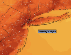
Tuesday:
Sunny. Highs around 80º. Northwest winds at 5-10mph.
Tonight:
Clear and comfortable. Lows in the mid 60s in the City, the 50s inland. Light winds.
Wednesday:
Sunny. Highs in the lower 80s.
Thursday:
Mostly sunny. Warmer. Highs in the mid to upper 80s.
Friday:
Mostly sunny. Hot and humid. Highs in the lower 90s.
Saturday:
Hazy, hot and humid. Chance of showers and storms. Highs around 90º.
Catch me on the Fox Business Network from 6am-9am this weekend and on the Weather Stream until 10am. Find us on Tubi, Roku TV and YouTube TV and as always the Fox Weather App. It’s Free!