Synopsis:
Scattered showers and an isolated thunderstorm is in the forecast for today with the passage of a cool front. It will not be a washout. Highs will be several degrees lower than the average high of 83º.
An evening shower or storm East, otherwise skies will clear. It’ll be cooler and much less humid than recent nights.
Tuesday and Wednesday will be beauties with near average readings and low humidity as high pressure moves in from the Great Lakes.
As the high shifts offshore a Southwesterly wind will take hold on Thursday and Friday (which is the first of July!) This will result in a rise in temperatures under a bright sky. It’ll be come hot and humid as we greet the new month.
Stay tuned.
Keep it here for a no hype, no nonsense forecast.
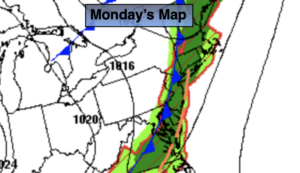
Monday:
Mostly cloudy with scattered showers and an isolated storm. It will not be a washout. Highs in the mid to upper 70s. Southwest to West winds at 5-10mph.
Tonight:
An evening shower or storm East, otherwise clearing skies. Cooler and less humid. Lows in the lower 60s in the City, the 50s inland. Northwest winds at 5-10mph.
Tuesday:
Sunny. Highs in the upper 70s.
Wednesday:
Sunny. Highs in the lower 80s.
Thursday:
Mostly sunny. Warmer. Highs in the mid to upper 80s.
Friday:
Mostly sunny. Hot and humid. Highs in the lower 90s.
Catch me on the Fox Business Network from 6am-9am this weekend and on the Weather Stream until 10am. Find us on Tubi, Roku TV and YouTube TV and as always the Fox Weather App. It’s Free!