Synopsis:
A couple of gems are expected for today and Wednesday. The sun will dominate. Readings today will be several degrees above the average high of 72º. Temperatures will be more seasonable for Wednesday as high pressure moves in from the Northwest.
Showers are possible Wednesday night and Thursday morning as a weak disturbance moves in from the West. The sun should return by afternoon on Thursday.
A warm front will swing through the region on Friday. It should come through precipitation free. Temperatures will pop during the afternoon and be close to ten degrees above average.
By Saturday a deep Southerly flow will develop around a Bermuda high. Readings will skyrocket to Summer-like readings under plenty of sunshine.
Stay tuned.
Keep it here for a no hype, no nonsense forecast.
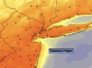
Tuesday:
Sunny, breezy and mild. Highs in the mid to upper 70s. West 10-20mph with higher gusts.
Tonight:
Clear and cool. Lows in the lower 50s in the City, the 40s inland. Northwest winds at 5-10mph.
Wednesday:
Mostly sunny. Highs around 70º.
Thursday:
Morning showers to a mix of sun and clouds. Highs around 70º.
Friday:
Partly sunny. Warmer. Highs in the upper 70s.
Saturday:
Partly sunny. Very warm and humid. Highs in the mid to upper 80s.
Catch me on the Fox Business Network from 6am-9am this weekend and on the Fox Weather Stream until Noon. Find us on Tubi, Roku TV and YouTube TV and as always the Fox Weather App. It’s Free!