Synopsis:
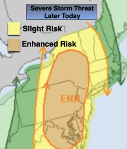
Monday will be warm ahead of a cool front. A mix of clouds and sun is expected. Showers and thunderstorms are expected during the late afternoon and evening. Some of the storms may become severe. Keep an eye to the sky for threatening weather after 4pm.
Skies will become mostly clear overnight. It’ll be a more comfortable night for sleeping.
A couple of gems are expected for Tuesday and Wednesday. A bright sky and near seasonable temperatures are expected as high pressure moves in from the Northwest.
Showers are possible Wednesday night and Thursday morning as a weak disturbance moves in from the West. The sun should return soon after on Thursday.
A warm front will swing through the region on Friday. It should come through precipitation free. Temperatures will pop during the afternoon and be well above the average high of 72º.
Stay tuned.
Keep it here for a no hype, no nonsense forecast.
Monday:
Sun and clouds. Warm. Afternoon showers and thunderstorms. Some of the storms maybe strong to severe. Highs in the upper 70s. South winds at 8-15mph.
Tonight:
Becoming mostly clear. It’ll be cooler than recent nights. Lows in the 50s throughout. West winds at 8-15mph.
Tuesday:
Sunny. Highs in the mid 70s.
Wednesday:
Mostly sunny. Highs around 70º.
Thursday:
Morning showers to a mix of sun and clouds. Highs around 70º.
Friday:
Partly sunny. Warmer. Highs in the upper 70s.
Catch me on the Fox Business Network from 6am-9am this weekend and on the Fox Weather Stream until Noon. Find us on Tubi, Roku TV and YouTube TV and as always the Fox Weather App. It’s Free!