Synopsis:
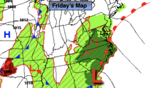
High pressure that has given our region pleasant days will move out to sea today. At the same time, a weak low in the Southeast will begin to move North. This will result in mainly grey skies, isolated showers and areas of morning fog for our Friday.
The disturbance will move to our North on Saturday. A mix of clouds and sun is expected. An isolated shower can’t be ruled out. Readings will be near the average high of 71º.
Sunday should be dry as weather systems remain weak. A bulb of warm air will move into the region. Temperatures will be above average by several degrees.
Monday will be warm ahead of a cool front. Showers are expected during the afternoon.
Slightly cooler readings are expected for Tuesday under a bright sky.
Stay tuned.
Keep it here for a no hype, no nonsense forecast.
Friday:
Mostly cloudy with isolated showers and areas of morning fog. Highs in the upper 60s. Northeast 5-10mph.
Tonight:
Cloudy with areas of fog and drizzle. Lows in the lower 60s in the City, the 50s elsewhere. Light Southeast winds.
Saturday:
More clouds than sun. Scattered showers possible. Slight chance of an afternoon isolated thunderstorm. Highs in the lower to mid 70s.
Sunday:
Partly sunny. Warmer. Highs in the upper 70s.
Monday:
Sun and clouds. Warm. Afternoon showers. Highs in the upper 70s.
Tuesday:
Mostly sunny. Highs in the lower to mid 70s.
Catch me on the Fox Weather Stream from 10am-1pm on Friday. Find us on Tubi, Roku TV and YouTube TV and as always the Fox Weather App. It’s Free!