Synopsis:
The stubborn Western Atlantic low will finally move toward the Southeast coast the next two days and weaken. High pressure to the Northeast will control our weather through today. This will result in the sun dominating the sky. There maybe coastal clouds from time to time.
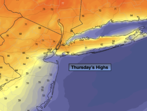
Temperatures will remain near or above the average high of 70º the next five days. It will be cooler at the coast.
Clouds and a scattered shower threat will be the story Friday into the weekend as the weakened low moves into the Southeast and then to the North into our area. It will not be a washout and in fact much of the time will be dry. It’ll be quite mild.
Monday will be warm ahead of a cool front. Showers are expected during the afternoon.
Stay tuned.
Keep it here for a no hype, no nonsense forecast.
Thursday:
Mostly sunny. Highs in the lower to mid 70s inland, the 60s at the coast. Northeast to East winds at 5-10mph.
Tonight:
Becoming mostly cloudy with areas of spotty drizzle developing. Lows in the 50s throughout. Northeast winds 5mph.
Friday:
Mostly cloudy with isolated showers. Highs in the upper 60s.
Saturday:
More clouds than sun. Scattered showers possible. Highs in the lower to mid 70s.
Sunday:
More clouds than sun. Scattered showers possible. Highs in the mid 70s.
Monday:
Sun and clouds. Warm. Afternoon showers. Highs in the upper 70s.
Catch me on the Fox Weather Stream from 10am-1pm on Thursday. Find us on Tubi, Roku TV and YouTube TV and as always the Fox Weather App. It’s Free!