Synopsis:
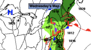
A weak low will move through the region today with scattered showers. If we’re lucky some some may shine during the afternoon hours. Highs will be a few degrees below the average of 68º.
Skies will clear tonight as the low moves well offshore.
Thursday will be the best day of the next 5 as high pressure moves overhead. This time around temperatures should be near or above average!
The next in a series of lows will move toward the East coast on Friday with another round of late day showers. That storm may hang around to our South and East on Saturday keeping the potential for some rain in the forecast. Our area will be on the line of rain to no rain. This is not etched in stone. One thing is for sure-Saturday will be unseasonably cool with readings remaining in the 50s.
By Mother’s Day, the storm should move far enough offshore for any morning clouds to give way to sunshine. It’ll be chilly and breezy as high pressure funnels in from Eastern Canada.
Stay tuned.
Keep it here for a no hype, no nonsense forecast.
Wednesday:
Scattered showers through midday. Some afternoon sun possible. Highs in the lower to mid 60s. East to Northwest winds at 5mph.
Tonight:
Becoming mostly clear. Lows in the mid 50s in the City, the upper 40s inland. Southeast to East winds at 5mph. Northwest winds at 5-10mph.
Thursday:
Mostly sunny. Highs 68º-74º.
Friday:
Mostly cloudy with showers possible during the afternoon. Highs in the lower 60s.
Saturday:
Potential for some rain. Breezy and unseasonably cool. Highs in the mid 50s.
Sunday:
Becoming mostly sunny. Breezy and cool. Highs around 60º.
Catch me on the Fox Weather Stream from 10am-1pm on Wednesday. Find us on Tubi, Roku TV and YouTube TV and as always the Fox Weather App. It’s Free!