Synopsis:
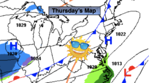
Today and Friday will feature high pressure dominating the Northeast. A mix of sun and clouds is expected with seasonal readings.
On Saturday a potent cold front will move toward the East coast. Ahead of the front it will be balmy with a period of rain and wind likely. A close eye will be kept on the backend of the front and developing storm along it for the afternoon hours. There is a low potential that the rain may change over to a period of snow before ending, this will most likely occur inland. Very strong winds will develop in the wake of the storm later Saturday and Saturday night into Sunday morning. Gusts over 50mph and possible.
Saturday night we Spring Ahead. Don’t forget to move your clock ahead one hour. Eastern Standard Time Ends at 2am and Daylight Saving Time resumes. It’s also a good time to change the batteries in your smoke and carbon monoxide detectors.
Sunday will be bright, windy and cold readings will at least ten degrees below the average high of 48º. Yes, it’s still Winter. We will gain an hour of daylight during the afternoon!
It’ll be a better feel for the beginning of the week with bright, mild conditions making a visit.
Spring officially arrives on March 20th and it couldn’t come any sooner.
Stay tuned.
Keep it here for a no hype, no nonsense forecast.
Thursday:
Mostly sunny. Highs in the upper 40s. Light and variable winds.
Tonight:
Mostly clear. Lows in the upper 30s in the City, the 20s and 30s inland. Light Southeast winds.
Friday:
Partly sunny. Highs in the lower 50s.
Saturday:
Rain. Mild to start with high in the 40s. Temperatures will fall during the day. Precipitation will possibly change to snow inland before ending. Becoming windy.
Sunday:
Partly sunny, windy and cold. Highs in the upper 30s.
Monday:
Partly sunny. Milder. Highs in the lower to mid 50s.