Synopsis:
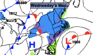
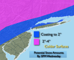
Low pressure will develop along the Virginia coast and move Northeast today. A period of wet snow is likely today. A mix with rain or all rain is likely parts of the region by the coast and over Southern regions. The potential is there for some accumulation from the City and to the North and West mainly on colder surfaces. Roadways are still very warm from the record breaking warmth of Monday and the March sun angle is now getting higher. Also, temperatures will remain above freezing, so all of these factors will contribute to much of the snow accumulating mainly on the grass and car tops. The wet snow and rain will taper off later today into this evening.
Skies will clear overnight with readings remaining just above freezing in the City. Inland temperatures will fall below freezing.
Thursday and Friday will feature high pressure dominating the Northeast. A mix of sun and clouds is expected with seasonal readings.
On Saturday a potent cold front will move toward the East coast. Ahead of the front it will be balmy with a period of rain and wind likely. A close eye will be kept on the backend of the front and developing storm along it for later Saturday. There is a low potential that the rain may change over to a period of snow before ending, this will most likely occur inland. Very strong winds will develop in the wake of the storm later Saturday and Saturday night into Sunday morning. Gusts over 50mph and possible.
Sunday will be bright, windy and cold readings will at least ten degrees below the average high of 48º.
Oh March, how we love thee!
Stay tuned.
Keep it here for a no hype, no nonsense forecast.
Catch me on the Fox Weather Stream/App from 2pm-5pm through Wednesday…
Wednesday:
A period of wet snow. Rain or a mix of rain and snow is possible to the South and along some coastal areas. Highs in the 30s to around 40º. East to Northeast winds at 5-10mph.
Tonight:
Wet snow or rain ending during the evening. Clearing skies. Lows in the lower to mid 30s in the City, the 20s inland. North winds at 5-10mph.
Thursday:
Mostly sunny. Highs in the upper 40s.
Friday:
Partly sunny. Highs in the lower 50s.
Saturday:
A period of rain. Mild to start with high in the 50s. Temperatures will fall during the day. Precipitation will possibly change to snow inland before ending. Becoming windy.
Sunday:
Partly sunny, windy and cold. Highs in the upper 30s.