Synopsis:
The cold will stick around through today courtesy of high pressure from the North. Skies will be sunny with readings struggling to reach freezing.
A moderation in temperatures is expected for Friday as clouds increase and thicken.
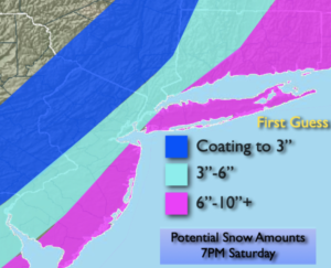
A deepening area of low pressure will be moving up and off the Mid-Atlantic and Northeast coast on Saturday. Most areas, especially toward the coast will receive an an accumulating snow. There is also the possibility of coastal flooding. Winds will be gusty. The exact track (as always) will determine what areas may get into the heavier snow. The map above is a “first guess” snowfall by 7pm Saturday. This is more of a generalization of where the lighter and heavier snowfall is expected. If the storm track is farther East, lighter accumulations will occur. If the track is closer to the coast most areas will receive a significant snowfall. This will be an intense storm off the coast. Again, nothing is etched in stone. Please keep it here for no hype, no nonsense forecast.
Sunday will be windy and very cold with mainly sunny skies.
Stay tuned..
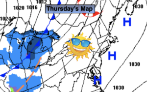
Thursday:
Sunny and cold. Highs in the lower 30s. East to South winds at 5-10mph.
Tonight:
Mostly clear. Lows in the mid to upper 20s in the City, teens inland. Light North winds.
Friday:
Increasing and thickening clouds. Highs in the mid 30s.
Saturday:
Snow. Steady and heaviest by the coast. Windy. Highs only in the 2os.
Sunday:
Mostly sunny, wind and cold. Highs only in the mid to upper 2os.
Monday:
Sunny. Highs in the mid 30s.