
Synopsis:
A moderation in temperatures is expected for Friday as clouds increase and thicken during the morning. Scattered snow showers are expected during the afternoon ahead of a developing storm East of Georgia.
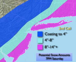
The deepening area of low pressure will be moving up and off the Mid-Atlantic and Northeast coast Friday night and Saturday. Snow will break out Friday night. The snow will become heavy at times along and to the South and East of I-95 on Saturday.. The exact track (as always) will determine how far West the heavy snow bands will get. There will be a sharp cutoff to the heavy snow to the North and West of the City. This will be the “Bust Zone”. If the storm track is farther East, lighter accumulations will occur. If the track is closer to the coast this area will also receive a significant snowfall. The map above is a “2nd call map” for snowfall by 7pm Saturday. Again, nothing is etched in stone. Please keep it here for no hype, no nonsense forecast. A “Last Call” snow amounts map will be issued Friday afternoon.
This will be an intense storm off the coast. Saturday will feature strong winds, falling temperatures, blowing snow and dangerous winds chills. It will be difficult to be outdoors. Coastal flooding is also possible at the times of high tide Saturday Morning.
Sunday will be windy and very cold with mainly sunny skies.
More tranquil conditions will be with us for the beginning of next week.
Stay tuned..
Tonight:
Becoming mostly cloudy. Lows in the mid to upper 20s in the City, teens inland. Light North winds.
Friday:
Thickening clouds. Scattered afternoon snow showers. Highs in the mid 30s. West to North winds at 5mph.
Saturday:
Snow. Steady and heaviest by the coast. Windy. Highs only in the 2os.
Sunday:
Mostly sunny, wind and cold. Highs only in the mid to upper 2os.
Monday:
Sunny. Highs in the mid 30s.
Tuesday:
Mostly sunny. Milder. Highs around 40º.