Synopsis:
Readings will moderate today to above average levels ahead of the next approaching Arctic front. The average high is 38º. Clouds will start the off the day but the sun will win the battle.
Another shot of bitter air will arrive on tonight and stick around through Thursday courtesy of high pressure from the North.
A moderation in temperatures is expected for Friday under partly sunny skies. We’ll crack freezing.
JMW will monitor a developing storm for Saturday. As of this writing, a deepening area of low pressure will be moving up and off the Mid-Atlantic and Northeast coast. The potential is there for snow and wind. At this time the potential for the heaviest snow area looks to be for Eastern areas. Again, nothing is etched in stone. Please keep it here for no hype, no nonsense forecast as you will be hearing a lot of chatter on this.
Stay tuned..
Tuesday:
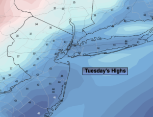
Mostly cloudy. More sun later in the day. A nice brief break from the cold. Highs in the lower to mid 40s. West to Northwest winds at 8-15mph.
Tonight:
Clear and frigid. Lows around 20º in the City, 8º-18º inland. Northwest winds at 10-15mph.
Wednesday:
Mostly sunny. Cold again. Highs in the mid to upper 20s.
Thursday:
Sunny and cold. Highs in the upper 20s.
Friday:
Sun will give way to increasing and thickening clouds. Highs in the mid 30s.
Saturday:
Potential for some snow and wind. Highs only in the 2os.