Synopsis:
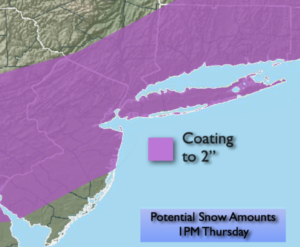
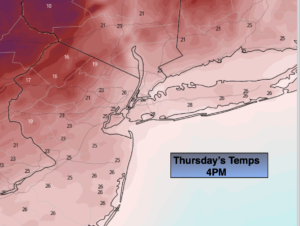
Thursday morning’s cold front has a punch to it with an area of snow developing along and behind the frontal passage. Any early morning light rain along the coast will go over to a period of light snow. The potential is there for a coating to 2″ by midday. Areas well to the North and well to the South may not get much (map above). Readings will start off the in the mid 30s but tumble into the 20s along the coast and teens inland by late afternoon as another bitter blast works in (temp maps above). This will cause a flash freeze and create icy conditions. The sun will return during the afternoon.
Tonight will be frigid will lows in the single digits inland, lower teens along the coast. Wind chills will be near 0º.
We’ll be in the ice box on Friday as Arctic high pressure continues to funnel in bitter air. Despite abundant sunshine readings will remain in the 20s.
Saturday will feature a storm developing off the mid-Atlantic coast. I have taken the potential of snow for coastal areas out of the forecast. A few snow showers are possible for coastal areas but that looks about it. It will be very cold on Saturday with readings remaining well below freezing under a mix of sun and clouds.
Sunday will feature more sun behind the departing system as we attempt to crack the freezing mark.
Monday will be more tolerable with readings getting above 32º.
Another Arctic blast will come our way on Monday with readings once again remaining well below freezing.
Stay tuned..
Thursday:
Early morning light rain along the coast will change to snow. Snow elsewhere during the morning, otherwise becoming partly sunny and turning colder during the afternoon. Early highs in the mid 30s, temperatures tumble into the 20s and teens during the afternoon. Northwest winds at 10-15mph.
Tonight:
Frigid. Lows in the lower teens in the City, the single digits inland. North winds at 10-20mph.
Friday:
Mostly sunny. Very cold. Highs in the lower to mid 20s.
Saturday:
Clouds and sun. A few coastal snow showers possible. Highs in the mid 20s.
Sunday:
Mostly sunny. Not as harsh. Highs in the lower to mid 30s.
Monday:
Mostly sunny. Much colder. Highs in the upper 20s.