Synopsis:
A mix of sun and clouds will greet us for Tuesday with chilly temperatures as high pressure moves in.
A “better feel” would be a good way to describe Wednesday as temperatures rise several degrees above the average high of 39º. A southwest wind will be responsible for our brief warm-up.
Early morning rain or snow showers are possible Thursday as a cold front pushers offshore. Readings will start off the in the mid 30s but tumble into the upper 20s by mid to late afternoon as another bitter blast works in.
We’re back in the freezer on Friday. Despite abundant sunshine readings will remain in the 20s.
Saturday will feature a storm developing off the Southeast coast. Most of the computer models have the storm sparring the region of significant snow. The European model has been steadfast in its solution with significant snow. By later this afternoon I will have an update on this potential. I am leaning toward putting some snow in the forecast.
Stay tuned..
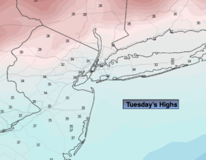
Tuesday:
Partly sunny. Chilly. Highs in the mid 30s. Northwest winds at 15-25mph.
Tonight:
Partly cloudy. Cold. Lows around 30º in the City, the teens and 20s inland. West to Southwest winds less than 5mph.
Wednesday:
Partly sunny. Milder. Highs in the mid 40s.
Thursday:
Chance of early morning rain or snow showers, otherwise mostly sunny and turning colder during the afternoon. Early highs in the mid 30s, temperatures tumble into the 20s during the afternoon.
Friday:
Sunny and frigid. Highs in the mid 20s.
Saturday:
Partly sunny. Cold. Highs in the upper 20s.