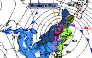
Synopsis:
The storm that gave the region all types of precipitation and wind will pull away this morning with rain ending early over Eastern areas. A few rain or snow showers are possible during the afternoon for Martin Luther King Jr. Day. Readings will be a few degrees above the average high of 39º.
Skies will become partly cloudy overnight. There will be a refreeze of any slush or standing water. Please use caution.
A mix of sun and clouds will greet us for Tuesday with chilly temperatures.
Wednesday we’ll have a respite with readings a few degrees above the average high under partly sunny skies. High pressure will dominate.
Colder conditions are expected for Thursday as a cold front moves offshore.
Arctic air will once again funnel in on Friday under mainly sunny skies.
Stay tuned..
Monday (Martin Luther King Jr. Day):
AM rain east, otherwise remaining mostly cloudy. Scattered afternoon rain and snow showers. Highs in the lower to mid 40s. Southwest to West winds at 15-25mph with gusts to 35mph.
Tonight:
Becoming partly cloudy, breezy and cold. Lows in the 20s throughout.
Tuesday:
Partly sunny. Chilly. Highs in the mid 30s.
Wednesday:
Partly sunny. Highs in the lower to mid 40s.
Thursday:
Partly sunny. Seasonal. Highs in the upper 30s.
Friday:
Sunny and frigid. Highs in the mid 20s.