Synopsis:
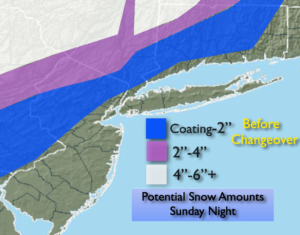
A storm will be moving up the Appalachians tonight. Snow inland will change over to a mix or rain. An accumulation is likely before the changeover. A coating to several inches is possible before the changeover depending on your location. Rain is expected along the coast. The concern is there for a period of high winds and coastal flooding late tonight into early Monday morning. Over an inch of rain is expected.
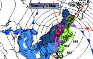
The storm will pull away Monday morning with rain ending early over Eastern areas. A few rain or snow showers are possible during the afternoon for Martin Luther King Jr. Day. Readings will be a few degrees above the average high of 39º.
A mix of sun and clouds will greet us for Tuesday with chilly temperatures.
Wednesday we’ll have a respite with readings a few degrees above the average high under partly sunny skies. High pressure will dominate.
Colder conditions are expected for Thursday as a cold front moves offshore.
Arctic air will once again funnel in on Friday under mainly sunny skies.
Stay tuned..
Tonight:
Snow starting this evening inland. Rain along the coast. Snow going over to a mix then rain overnight North and West. Temperatures rising into the 40s along the coast. Rising through the 20s and 30s inland. Increasing East winds at 15-30mph with gusts to 40mph inland, gusts to 50 to 60mph at the coast and over Eastern Long Island.
Monday (Martin Luther King Jr. Day):
AM rain east, otherwise remaining mostly cloudy. Scattered afternoon rain and snow showers. Highs in the lower to mid 40s. Southwest to West winds at 15-25mph.
Tuesday:
Partly sunny. Chilly. Highs in the mid 30s.
Wednesday:
Partly sunny. Highs in the lower to mid 40s.
Thursday:
Partly sunny. Seasonal. Highs in the upper 30s.
Friday:
Sunny and frigid. Highs in the mid 20s.