Synopsis:
The holiday weekend will be decent for travel but chilly with readings well below the average high of 50º. Today will be cold under a bright sky as high pressure moves in. More clouds are expected for Sunday as a weak upper level low approaches.
Monday will be blustery and cold behind the intensifying low off the New England coast. Readings will moderate to near average by midweek. High pressure over the Southeast will keep it quiet in our area with a decent amount of sun.
You know where to find a no hype, no nonsense forecast.
Stay tuned.
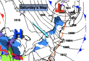
Saturday:
Mostly sunny, breezy and cold. Highs in the lower 40s. West to Northwest winds at 15-25mph.
Tonight:
Becoming mostly cloudy. Lows in the lower 30s in the City, the 20s elsewhere. West winds diminishing to 5mph.
Sunday:
More clouds. Chilly. Highs in the lower 40s.
Monday:
Partly sunny. Breezy. Highs in the lower 40s.
Tuesday:
Partly sunny. Highs in the mid 40s.
Wednesday:
Partly sunny. Highs in the mid to upper 40s.