Synopsis:
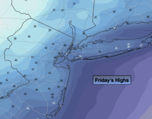
Conditions will change rapidly for shoppers today. A cold front will move through during the morning with scattered showers. The sun will return by midday and the wind increase and become gusty. Highs will be in the morning and fall later in the day through the 40s and into the upper 30s inland.
All areas tonight should be below freezing as Canadian air funnels in on a busy wind. Bundle up!
The holiday weekend will be decent for travel. Saturday will be cold under a bright sky as cold high pressure moves in. A mix of sun and clouds is expected for Sunday.
The system we were watching for possible snow showers Sunday night looks very disorganized. I have taken the chance out of the forecast.
Monday will be blustery and cold behind the intensifying low off the New England coast. Tuesday will be chilly with readings a few degrees below the average high of 50º. Highs pressure over the Southeast will keep it quiet in our area.
You know where to find a no hype, no nonsense forecast.
Stay tuned.
Friday:
Morning showers giving way to mostly sunny skies. Becoming windy. Highs will occur during the morning and fall into and through the 40s and upper 30s inland during the day. West to Northwest winds at 15-30mph with higher gusts.
Tonight:
Mostly clear, windy and cold. Lows in the lower 30s in the City, the 20s elsewhere. Wind chills will be in the upper teens and 20s. West to Northwest winds at 15-30mph with higher gusts.
Saturday:
Sunny, windy and cold. Highs in the lower 40s.
Sunday:
Sun and clouds. Chilly. Highs in the lower 40s.
Monday:
Partly sunny, breezy and cold. Highs around 40º.
Tuesday:
Partly sunny. Chilly. Highs in the mid 40s.