Synopsis:
Today will start off with abundant sunshine as high pressure over Eastern Canada noses into the region. The sun will be filtered by high clouds later in the afternoon. Highs will be just below the average of 61º.
A low pressure system will begin to move in from the South and West on Friday. Clouds will dominate the sky, but some peeks of sun are possible during the morning. Showers will move in by mid to late afternoon. It’ll be cool. A period of rain is likely Friday night as a warm front moves through.
Saturday will feature mainly cloudy skies with the possibility of scattered showers as the low sits over the area and weakens.
Halloween Sunday will feature a mix of sun and clouds with the possibility of isolated showers. Temperatures will be comfortable for the trick or treaters!
Keep it here for a no hype-no nonsense forecast.
Stay tuned.
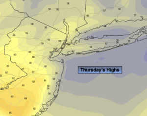
Thursday:
Sunshine filtered by high clouds during the afternoon. Highs in the upper 50s. Northeast winds at 5-10mph.
Tonight:
Partly cloudy. Lows in the upper 40s in the City, the 30s and 40s inland. Northeast winds at 5-10mph.
Friday:
Thickening clouds with afternoon showers possible. Highs in the upper 50s.
Saturday:
Mostly cloudy with scattered showers. Highs in the lower 60s.
Halloween:
Clouds and sun. Isolated showers possible. Highs in the lower 60s.
Monday:
Mostly sunny. Highs in the lower 60s.