Synopsis:
The Nor’easter that gave many areas flooding rains and high winds will spin Southeast of Long Island today. Clouds should break for some sun. The winds will be strongest during the morning and begin to diminish some through the afternoon. Temperatures will be just below the average high of 61º.
Thursday we’ll dry out as the sun dominates as high pressure moves in .
Another low pressure system will begin to move in from the South on Friday. Early sun will give way to the potential of late day showers. A period of rain is likely Friday night. Saturday will feature mainly cloudy skies with the possibility of scattered showers.
Halloween Sunday will feature a mix of sun and clouds with the possibility of isolated showers. Temperatures will be comfortable for the trick or treaters!
Keep it here for a no hype-no nonsense forecast.
Stay tuned.
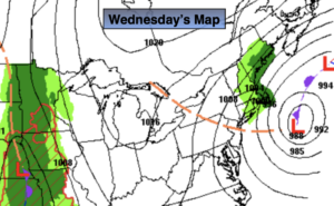
Wednesday:
Clouds giving way to some sun. Windy. Highs around 60º. North winds at 15-30mph and diminishing some during the afternoon.
Tonight:
Clear. Lows in the upper 40s in the City, the lower 40s inland. North winds at 5-10mph.
Thursday:
Mostly sunny. Highs around 60º.
Friday:
Thickening clouds with afternoon showers possible. Highs in the upper 50s.
Saturday:
Mostly cloudy with scattered showers. Highs in the lower 60s.
Halloween:
Clouds and sun. Isolated showers possible. Highs in the lower 60s.