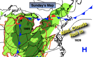
Synopsis:
Today will feature a mix of sun and clouds with the clouds becoming more dominate during the day. It will be mild with readings well above the average high of 70º as a Southwesterly flow around offshore high pressure prevails.
A frontal boundary to our North and West will move closer to the region tonight. This will result in scattered showers and even the possibility of a rumble of thunder.
On Monday, the weak cool front will move in with spotty showers. There will be dry times. The threat of showers will continue into Tuesday morning as the front washout over the region. A peek of sun is possible later in the day.
The sun will return Wednesday and Thursday with seasonal readings.
Keep it here for a no hype-no nonsense forecast.
Stay tuned.
Sunday:
Sun to clouds. Warmer. Highs in the mid to upper 70s. West to Southwest winds at 5mph.
Tonight:
Scattered showers with a rumble of thunder possible. Lows in the 60s, a few upper 50s well inland. Light and variable wind.
Monday:
Mostly cloudy. Spotty showers. Highs in the lower 70s.
Tuesday:
Mostly cloudy. Scattered showers in the morning. Highs around 70º.
Wednesday:
Becoming mostly sunny. Highs around 70º.
Thursday:
Sunny. Highs in the lower 70s.