Synopsis:
The first weekend of the new month will be a winner as high pressure sits offshore. Mainly sunny skies are anticipated with moderating temperatures as the wind turns to the Southwest.
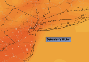
Today will be a Fall classic with readings getting above average with abundant sunshine. It will be warmer on Sunday with some areas approaching 80º. The average high is 71º.
By Monday, a weak cool front will approach. More clouds than sun is expected. Scattered showers are possible, especially in the afternoon. The threat of showers will continue into Tuesday as the front washout over the region.
The sun will return by Wednesday with seasonal readings.
Keep it here for a no hype-no nonsense forecast.
Stay tuned.
Saturday:
Sunny. Highs in the lower to mid 70s. West to Southwest winds at 5-10mph.
Tonight:
Mostly clear. Lows in the lower to mid 60s in urban regions, the 40s and 50s inland. West to Northwest winds less than 5mph.
Sunday:
Mostly sunny. Warmer. Highs 75º-80º.
Monday:
Mostly cloudy. Scattered showers possible. Highs in the mid 70s.
Tuesday:
Mostly cloudy. Scattered showers. Highs in the lower 70s.
Wednesday:
Becoming mostly sunny. Highs around 70º.