Synopsis:
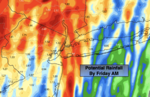
A significant cold front will be working toward the region today and tonight. Ahead of it a tropical airmass will make it feel quite uncomfortable today. Mostly cloudy skies are expected. Scattered showers will be with us throughout the day. There will be dry times. As there front approaches after 5pm areas of heavy rain will move in. The on and off rain will continue into early Friday morning. One to two inches or more of rain is possible. The jackpot for the heaviest rain looks to be North and West of the City.
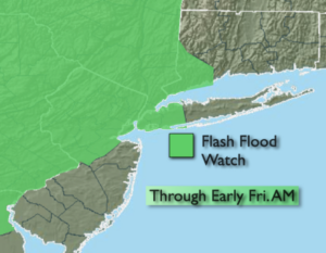
A Flash Flood Watch is in effect until early Friday morning for most of the tri-state area, excluding Eastern and Southern region. Flooding of streets, highways, streams and basements is possible. Never drive through a flooded roadway. You don’t know how deep that water is. TURN AROUND, DON’T DROWN.
The front will push offshore Friday with any early morning showers giving way to sunny skies. Relief will have arrived from the high humidity and it will feel the season- Fall.
The first weekend of autumn looks delightful as high pressure over the Southeast results in seasonal sunshine both days. Readings will be at or below the average high of 74º.
Stay tuned.
Thursday:
Mostly cloudy with scattered showers. Areas of heavy rain move in from West to East later in the afternoon and evening. Humid and breezy. Highs in the upper 70s. Southeast winds at 15-25mph with gusts to 35mph.
Tonight:
Areas of heavy rain. Slight chance of thunderstorms. Much cooler by morning. Lows around 60º in the City, the 50s inland. Southeast winds at 8-12mph.
Friday:
Early morning showers will give way to sunny skies. Cooler and much less humid. Highs in the lower 70s.
Saturday:
Mostly sunny. Highs in the mid 70s.
Sunday:
Sunny. Breezy. Highs in the lower 70s.
Monday:
Sunny. Cool. Highs in the lower 70s.