Synopsis:
A cool front will washout over the area today. At the same time a weak tropical low will be off the coast. There will be more clouds than sun. Isolated showers and a possible storm are possible with the interaction of these two systems. The majority of the day will be dry. It’ll be cooler than recent days.
Clouds and areas of drizzle are possible overnight with the flow off the ocean.
On Friday, with the low off the coast there’s still a chance of an isolated shower. Clouds should give way to some sun.
The last weekend of Summer is looking fairly decent. By Saturday the atmosphere will dry out as high pressure builds into the region. Sunday will be the sunnier day of the weekend. Both days will warm.
Warm, bright days are expected into the beginning of next week.
Stay tuned.
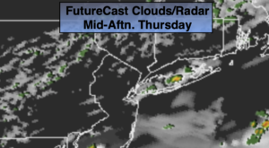
Thursday:
Mostly cloudy. Isolated showers and a possible storm. The majority of the day will be dry. Highs in the upper 70s. Northeast to East winds at 5-10mph.
Tonight:
Mostly cloudy with possible drizzle. Lows in the 60s throughout. Northeast winds at 5-10mph.
Friday:
Clouds, some sun. Isolated showers. Highs in the upper 70s.
Saturday:
Partly sunny. Highs in the lower 80s.
Sunday:
Sunny. Highs in the lower 80s.
Monday:
Sunny. Highs in the lower 80s.