Synopsis:
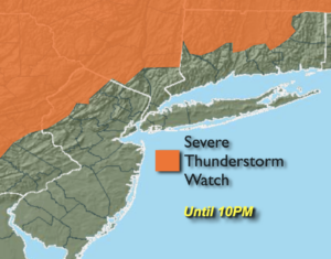
A cool front will approach this evening and tonight with scattered showers and storms. Some of the storms maybe severe North and West of the City. A Severe Thunderstorm Watch is in effect until 10PM for areas North & West of the City (map above).
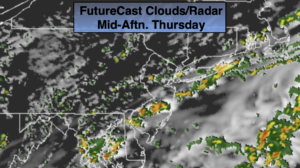
The front will washout over the area on Thursday at the same time A weak tropical low will be off the coast. Mainly cloudy skies are expected. Isolated showers are possible during the morning. Scattered showers and storms are possibly during the day with the interaction of these two systems.
On Friday with the low off the coast there’s still a chance of an isolated shower. Clouds should give way to some sun.
The last weekend of Summer is looking fairly decent. By Saturday the atmosphere will dry out as high pressure builds into the region. Sunday will be sunnier day of the weekend. Both days will warm.
Stay tuned.
Tonight:
Mostly cloudy with scattered showers and storms. Some of the storms maybe severe early to the North and West. Lows around 70º in the City, the 60s inland. Southeast to South winds at 5mph.
Thursday:
Mostly cloudy. Isolated showers. Scattered isolated afternoon storms. Highs in the upper 70s. Northeast to East winds at 5-10mph.
Friday:
Clouds, some sun. Spotty showers. Highs in the upper 70s.
Saturday:
Partly sunny. Highs in the lower 80s.
Sunday:
Sunny. Highs in the lower 80s.
Monday:
Sunny. Highs in the lower 80s.