Synopsis:
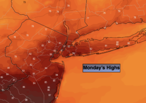
A warm flow from the South and West will continue into today as high pressure remains over the Western Atlantic. It’ll be mainly sunny with readings several degrees above the average high of 78º.
A weak cool front will washout over the region on tonight. Scattered showers are possible. Clouds will give way to sun on Tuesday. A flow off the cooler Atlantic will bring temperatures down to more seasonal levels.
By Wednesday, another push of warm, humid air will work in under mostly sunny skies.
A cool front will approach Wednesday night and Thursday with scattered showers.
A weak tropical low will be off the coast on Friday. The potential is there for a few showers if the low is close enough. A mix of sun and clouds is expected.
Stay tuned.
Today:
Mostly sunny. Warm. Highs in the mid 80s. Northwest winds at 5-10mph.
Tonight:
Mostly cloudy. Scattered showers possible. Lows in the mid to upper 60s in the City, around 60º inland. North to Northeast winds at 5-10mph.
Tuesday:
Clouds will give way to partly sunny skies. Cooler. Highs in the upper 70s.
Wednesday:
Hazy, warm and humid. Highs in the mid 80s.
Thursday:
Clouds, some sun. Scattered showers. Highs around 80º.
Friday:
Clouds, some sun. Spotty showers. Highs in the upper 70s.