Synopsis:
High pressure off the Eastern Seaboard will continue to dominate our area. A Southwesterly flow will develop. This will result in warmer and more humid conditions today. A Summery Sunday for sure.
Not much will change for the beginning of the week. Mainly sunny skies are expected. The high will be to the Southeast and a weak cool front will washout over the region on Tuesday. Monday will be warm. On Tuesday a flow off the cooler Atlantic will bring temperatures down to more seasonal levels-the upper 70s.
By Wednesday, another push of warm, humid air will work in. A cool front will approach Wednesday night and Thursday with scattered showers and storms.
Stay tuned.
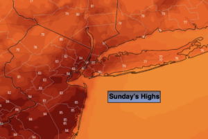
Today:
Sunny, warmer and a bit more humid. Highs in the lower to mid 80s. Southwest winds at 10-20mph.
Tonight:
Mostly clear. Warmer than recent nights. Lows around 70º in the City, the 60s inland. Southwest to West winds at 5-10mph.
Monday:
Mostly sunny. Warm. Highs in the mid 80s.
Tuesday:
Partly sunny. Highs in the upper 70s.
Wednesday:
Partly sunny. Warmer. Isolated late day storm. Highs in the mid 80s.
Thursday:
Clouds and sun. Spotty showers. Highs around 80º.