Synopsis:
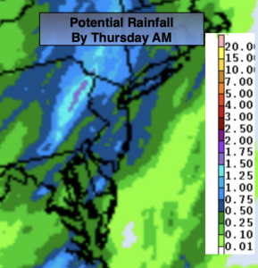
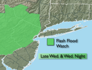
Today will feature a mix of sun and clouds. It will be warm and humid. There’s only a slight chance of a spotty late day storm as a cool front approaches. As the system moves in tonight the rain may come down heavy for a time over parts of the region. A Flash Flood Watch has been posted for Northern and central NJ and parts of lower NY state (map above). The ground is still saturated from Ida. Between a half inch to two inches of rain may fall (map above). This may cause flash flooding of streets, streams and some basements. Never drive through a flooded roadway. You don’t know how deep that water is. TURN AROUND, DON’T DROWN. This will not be a repeat performance of last week. Again, areas of potentially heavy rain is expected tonight.
Thursday will be mostly cloudy and cooler. Scattered showers are possible just about anytime as the front takes its sweet old time moving offshore.
Friday through the weekend look fantastic as high pressure moves across the region. Mainly sunny skies and near seasonal temperatures are expected Friday and Saturday. By Sunday, the high will move off the coast and a Southwesterly flow will develop. This will result in warmer and more humid conditions.
Stay tuned.
Today:
Sun and clouds. Humid and breezy. Slight chance of spotty late day storms. Highs in the lower to mid 80s. South winds at 10-20mph.
Tonight:
Scattered showers and storms. Some of the rain maybe heavy. Lows in the 60s throughout. South to Northwest at 5-10mph.
Thursday:
Mostly cloudy with scattered showers. Cooler. Highs in the mid 70s.
Friday:
Mostly sunny. Highs in the mid to upper 70s.
Saturday :
Sunny. Highs in the upper 70s.
Sunday:
Mostly sunny. Warmer and more humid. Highs in the lower to mid 80s.