Synopsis:
Most rivers will go below flood stage by late today, the exception being the Passaic which remain above flood stage through the weekend. Our thoughts and prayers go out to the affected communities.
Cool Canadian high pressure will dominate our weather through tonight. It will be a gem today with abundant sunshine and below average readings for early September.
Tonight will once again be chilly with readings inland dipping into the upper 40s.
The Labor Weekend will make most smile! High pressure will dominate Saturday with plenty of sun. A couple of disturbances will move through Sunday and Monday. Both days will feature a mix of sun and clouds. Spotty showers are possible Sunday afternoon and then again early Monday morning. I wouldn’t cancel any outdoor plans as much of the time will be dry.
Keep it here for a no nonsense, no hype forecast.
Stay tuned.
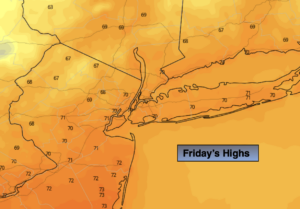
Today:
Sunny. Highs in the lower 70s. Northwest winds at 8-12mph.
Tonight:
Partly cloudy and cool. Lows in the 50s, a few upper 40s well inland. Northwest winds under 5mph.
Saturday:
Mostly sunny. Highs in the mid 70s.
Sunday:
Clouds and sun. Spotty afternoon showers possible. Highs in the mid 70s.
Labor Day Monday:
Early morning shower, otherwise mostly sunny. Highs around 80º.
Tuesday:
Partly sunny. Highs around 80º.