Synopsis:
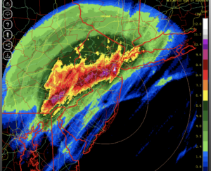
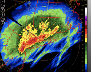
Historic rainfall from the remnants of Hurricane Ida resulted in devastating flooding from the I-95 corridor and to the North and West. 3-8″ of rain fell. Some regions received 2 months of rain within 8 hours. Our thoughts go out to those affected by the flooding rains.
A well deserved break is on the way today. It’ll be a bright, cool and breezy September day. Readings will be close to ten degrees below the average high of the lower 80s.
Tonight will have a fall feel with most readings in the 50s.
Friday will be a gem as cool high pressure influences the region. Abundant sunshine is expected with low humidity.
The Labor Weekend will make most smile! High pressure will dominate Saturday with abundant sunshine. A weak cool front will sweep through Sunday with a mix of sun and clouds. Spotty showers are possible. Monday-the holiday will be a winner seasonal readings.
Keep it here for a no nonsense, no hype forecast.
Stay tuned.
Thursday:
Becoming mostly sunny. Breezy. Cool. Highs in the lower to mid 70s. Northwest winds at 10-20mph with higher gusts.
Tonight:
Clear and cool. Lows in the 50s throughout. Northwest winds diminishing to 5-10mph.
Friday:
Sunny. Highs in the lower 70s.
Saturday:
Sunny. Highs in the mid 70s.
Sunday:
Partly sunny. Spotty shower possible. Highs around 80º.
Labor Day Monday:
Partly sunny. Highs around 80º.