Synopsis:
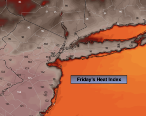
Today will be the last day of the heat. It’ll be mostly sunny, hot and humid. The heat index will be near 100º.
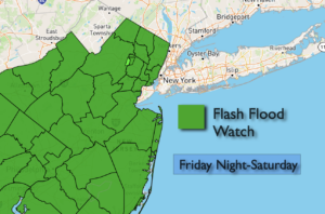
A cool front will approach later today this will result in spotty storms developing later this afternoon. Torrential rain is possible in any of the storms. On and off showers with local downpours are likely Saturday. Since the ground is saturated in many areas from Henri’s passage last weekend a Flash Flood Watch has been posted for most of NJ. One to three inches of rain is possible in spots.
Sunday will be the better half of the weekend. A mix of sun and clouds is expected with readings near the average high of the lower 80s.
Warmer and more humid conditions will return for the beginning of the week.
Keep it here for a no nonsense, no hype forecast.
Stay tuned.
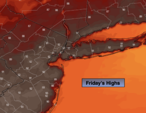
Friday:
Hazy, hot and humid. Scattered storms possible toward evening. Highs in the lower 90s. Heat index near 100º. Northwest winds at 5-10mph.
Tonight:
Mostly cloudy. Scattered showers and storms with torrential rain. Lows around 70º in the City, the 60s inland. Northeast winds at 5-10mph.
Saturday:
Much cooler. Mostly cloudy with scattered showers. Locally heavy rain in spots. Highs in the mid 70s.
Sunday:
Partly sunny. Highs in the lower 80s.
Monday:
Hazy, warm and humid. Highs in the mid 80s.
Tuesday:
Hazy, warm and humid. Highs in the mid 80s.