Synopsis:
Typical August conditions are in the forecast through Friday. Hazy, hot and humid days-the 3 H’s will be with us as a Bermuda High dominates our area. The heat index both today and Friday will be near 100º.
A cool front will pass through Friday night. Ahead of it Friday, late day and evening, will be the chance of thunderstorms. Relief will arrive Saturday as the heat lowers considerably, but we’ll pay a bit of a price with showers. Sunday will be the better half of the weekend. A mix of sun and clouds is expected with readings near the average high of the lower 80s.
Warmer and more humid conditions will return for the beginning of the week.
Keep it here for a no nonsense, no hype forecast.
Stay tuned.
Thursday:
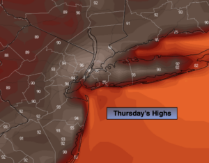
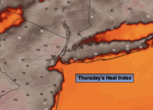
Hazy, hot and humid. Highs in the lower 90s. Heat index near 100º.
Tonight:
Mostly cloudy. Warm. Lows in the mid to upper 70s in the City, the 60s inland. Southwest winds less than 5mph.
Friday:
Hazy, hot and humid. Scattered storms possible toward evening. Highs around 90º.
Saturday:
Much cooler. Mostly cloudy with scattered showers. Highs in the mid 70s.
Sunday:
Partly sunny. Highs in the lower 80s.
Monday:
Hazy, warm and humid. Highs in the mid to upper 80s.