Synopsis:
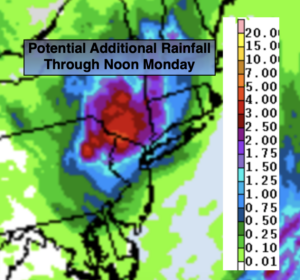
Tropical system Henri will move into Southern NY state overnight and Monday before moving back East and dissipating. This now looks like a potential heavy rain event for the areas from I-95 and to the North and West. An additional several inches of rain is possible in these areas (map above). Devastating flooding is likely in areas with the heaviest training rain. A Flood Watch continues through Monday for the entire tri-state area. Never drive through flooded roadways. You don’t know how deep the water is. TURN AROUND, DON’T DROWN. Over parts of central and Southern NJ and parts of Long Island much lighter rain is expected.
Heavier areas of morning rain Monday should begin to lighten and become more scattered. A bit of afternoon sun is possible.
Hazy, hot and humid conditions are expected for Tuesday through Thursday as high pressure builds over the Western Atlantic.
A cool front will pass through Thursday night. Relief will arrive Friday as the heat and humidity lowers.
Keep it here for a no nonsense, no hype forecast.
Stay tuned.
Tonight:
On and off rain. Local downpours with flooding in the persistent bands. Lows in the lower 70s in the City, the upper 60s inland. West to Southwest winds diminishing to 5-1omph.
Monday:
Areas of morning rain, otherwise scattered showers. Some afternoon sun is possible. Highs around 80º.
Tuesday:
Hazy, hot and humid. Highs near 90º.
Wednesday:
Hazy, hot and humid. Highs near 90º.
Thursday:
Hazy, hot and humid. Highs near 90º.
Friday:
Mostly sunny. Not as warm. Less humid. Highs in the mid 80s.