Synopsis:
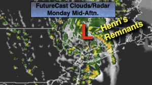
The remnants of Henri will move from Southern NY State into Southern New England thorough tonight. There will still be banding to the areas of heavy rain around it’s circulation this morning. In between the pivoting bands will be dry times. Overall the coverage of heavy rain will diminish during the day. Major flooding is likely in areas with the heaviest training rain. A Flood Watch continues through today for the entire tri-state area, excluding Ocean county. Never drive through flooded roadways. You don’t know how deep the water is. TURN AROUND, DON’T DROWN. The sun will shine from time to time later today.
We’ll finally get to dry out tonight as the entire system exits the region.
Hazy, hot and humid conditions are expected for Tuesday through Thursday as high pressure builds over the Western Atlantic.
A cool front will pass through Thursday night. Relief will arrive Friday as the heat and humidity lowers.
Keep it here for a no nonsense, no hype forecast.
Stay tuned.
Monday:
Areas of morning rain (locally heavy), otherwise scattered showers. Some afternoon sun is possible. Highs around 80º. Southwest winds at 8-12mph.
Tonight:
Partly cloudy. Lows in the lower 70s in the City, the upper 60s inland. Northwest winds 5-1omph.
Tuesday:
Hazy, hot and humid. Highs near 90º.
Wednesday:
Hazy, hot and humid. Highs near 90º.
Thursday:
Hazy, hot and humid. Highs near 90º.
Friday:
Mostly sunny. Not as warm. Less humid. Highs in the mid 80s.