Synopsis:
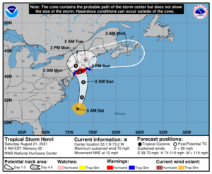
Today will be the calm before the storm. And that “storm” right now is what is to be Hurricane Henri making a most likely landfall over Long Island on Sunday.
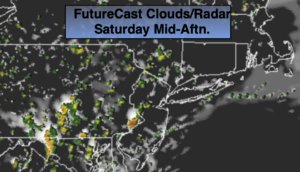
A mix of sun and clouds is expected for today. Scattered showers and storms are possible ahead of Henri. It won’t be raining all the time and much of the day will be decent for all areas.
Henri is expected to move North up and offshore the Mid-Atlantic coastline through tonight. The projected track is above. Long Island has the greatest potential of a landfall sometime Sunday midday. The weather will deteriorate Sunday especially in the immediate NYC area and to the East. Depending on the exact track, these areas will experience heavy rain and possible tropical force to hurricane force wind gusts Sunday and Sunday night. Father to the West, areas of heavy rain can be expected but the winds will not be severe.
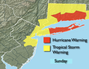
A Hurricane Warning is in effect for Suffolk County Long Island and South coastal Connecticut for Sunday. A Tropical Storm Warning is in effect for Nassau County, all of New York City, Southern Westchester County and Northeast NJ South to Monmouth County (map above).
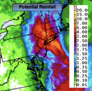
A Flood Watch is in effect for most of the region for Sunday into Monday morning. Rainfall of two to six inches is possible. Flooding of streets, streams, rivers and prone basements could occur.
A Storm Surge Warning is in effect for Sunday for coastal regions East of NYC. A surge of two to five feet is possible.
High surf and dangerous rip currents are a definite both weekend days.
Now is the time in the Hurricane Warning area to prepare for possible hurricane conditions. Prepare for the worst hope for the best.
Hazy, warm and humid conditions will be with us for early next week.
Keep it here for a no nonsense, no hype forecast.
Stay tuned.
Saturday:
Hazy sun and clouds. Humid. Scattered showers and storms. Highs in the lower 80s. East South east winds at 5-10mph.
Tonight:
Scattered showers and possible storms. Lows in the lower 70s in urban areas the upper 60s inland. Northeast winds at 10-15mph.
Sunday:
Mostly cloudy. Humid. Heavy rain and high winds likely for the NYC vicinity and Eastern areas. Areas of heavy rain South and West. Highs around 80º.
Monday:
Partly sunny. Humid. Scattered showers possible. Highs in the lower to mid 80s.
Tuesday:
Hazy, hot and humid. Highs near 90º.
Wednesday:
Hazy, hot and humid. Highs near 90º.