Synopsis:
High pressure off the coast will result in a Southerly wind and a tropical connection. It will quite humid the next 24 hours. Today will feature a mix of clouds and sun. An isolated shower is possible. Readings will be near average high of the mid 80s.
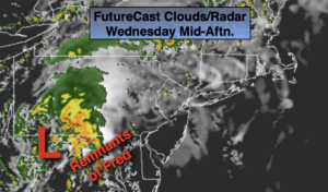
The remnants of Tropical Storm Fred will move up the Appalachians and be at our latitude tonight and early Thursday morning. The potential is there for a period of rain, mainly for the Northern Half of the tri-state area. Once the system moves to our Northeast during the day Thursday any showers will give way to some sun.
Friday through the weekend look warm and moderately humid. A mix of sun and clouds is expected. There will not be a dominate weather system over the East coast. This will result in the chance of spotty showers or storms both weekend days. I wouldn’t cancel my outdoor plans.
Keep it here for a no nonsense, no hype forecast.
Stay tuned.
Wednesday:
Clouds and sun. Humid. An isolated shower possible. Highs in the lower to mid 80s. Southeast winds at 8-12mph.
Tonight:
Mostly cloudy. Muggy. A few periods of rain possible, mainly for the Northern half of the region. Lows in the lower to mid 70s in urban areas the 60s inland. South to Southeast winds at 5mph.
Thursday:
Early morning showers in spots, otherwise a mix of clouds and sun. Humid. Highs in the mid 80s.
Friday:
Sun and clouds. Warmer. Humid. Highs in the mid to upper 80s.
Saturday:
Sun and clouds. Spotty PM storm. Highs in the mid 80s.
Sunday:
Sun and clouds. Spotty PM storm. Highs in the mid 80s.