Synopsis:
High pressure will move off the Eastern seaboard today and a weak disturbance to our West will result in more clouds. An isolated shower is possible, especially inland. Much of today will be dry.
Skies will mainly be grey Tuesday through Thursday as a moist Southerly flow develops around offshore high pressure. It will be more humid. Scattered showers are possible just about anytime.
The remnants of Tropical Storm Fred will move up the Appalachians and be at our latitude Wednesday night and Thursday. At this time, a period of steadier rain is possible. We’ll fine-tune that time period over the next 24 hours. Temperatures through Thursday will be slightly below the average high of the lower to mid 80s.
The low should push off the coast by Friday resulting in more sunshine and warmer temperatures.
Keep it here for a no nonsense, no hype forecast.
Stay tuned.
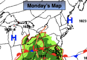
Monday:
Clouds and sun. Isolated shower West. Highs in the lower 80s. Northeast to Southeast winds at 5-10mph.
Tonight:
Mostly cloudy, becoming muggy. An isolated shower is possible. Lows around 70º in urban areas the 60s inland. South to Southeast winds at 5mph.
Tuesday:
Mostly cloudy. Spotty showers possible. More humid. Highs in the upper 70s.
Wednesday:
Mostly cloudy. Scattered showers. Humid. Highs around 80º.
Thursday:
Cloudy. A period of rain possible. The rain could be heavy. Humid. Highs in the upper 70s.
Friday:
Sun and clouds. Warmer and more humid. Highs in the mid 80s.