Synopsis:
August’s ugly side will be with us the rest of the week as high pressure builds over the Western Atlantic- a Bermuda high. This is very typical for this time of the year. The dog days of August will be upon us. Hazy, increasingly hot and humid conditions can be expected. The heatwave will begin today and last through Friday. A spotty shower or storm is possible this morning (in and around NYC and to the North) and then again later today or this evening. Most of the day will be rain-free.
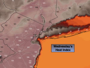
The heat will peak on Thursday. The heat index, the way it actually feels with the temperature and humidity combined will reach between 100º-100º all three days.
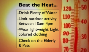
Please listen to your body. If you feel weak or disorientated take a break. Stay in a cool environment, if possible and drink plenty of water.
A cool front will approach on Saturday. Spotty storms are likely. This will bring relief from the oppressive conditions. By Sunday, true relief will arrive with readings just below the average high of the mid 80s and much lower humidity as Canadian high pressure get our applause. Sunday will by far be the better half of the weekend. Abundant sunshine is expected.
Keep it here for a no nonsense, no hype forecast.
Stay tuned.
Today:
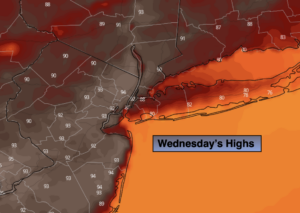
Hazy, hot and humid. Spotty late day storms. Highs in the lower 90s. Heat index 100º-105º. South to Southwest winds at 8-12mph.
Tonight:
A spotty evening storm, otherwise partly cloudy. Muggy and very warm. Lows in the upper 70s in urban areas, the lower 70s inland. Southwest winds at 5mph.
Thursday:
Oppressive heat. Hazy and humid. Highs 95º-100º. Heat index 100º-110º.
Friday:
Hazy, hot and humid. Highs in the mid to upper 90s. Heat index near 100º-105º.
Saturday:
Hazy, very warm and humid. Scattered storms. Highs in the upper 80s.
Sunday:
Sunny. Not as warm. Much less humid. Highs in the lower 80s.