Synopsis:
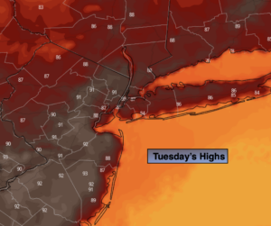
Today will be hot, hazy and moderately humid as the heat peaks over the region. Readings in most areas away from the coast should be around 90º.
A cool front will approach tonight with scattered showers late. .
On Wednesday relief from the heat will have arrived. A mix of sun and clouds is expected with an isolated storm possible later in the day.
More clouds are expected for Thursday. Showers are possible just about anytime as an energized jet stream moves through and another cool front approaches. It will not be a washout.
Friday and Saturday will be winners with abundant sunshine and low humidity as a refreshing Northwest winds dominates.
Stay tuned.
Keep it here for a no nonsense, no hype forecast.
Tuesday:
Mostly sunny and hot. Cooler at the coast. Highs around 90º. Southwest winds at 8-12mph.
Tonight:
Mostly clear early, becoming mostly cloudy late with scattered showers. Lows around 70º in the City, the 60s inland. Winds becoming North less than 5mph.
Wednesday:
Partly sunny. An isolated late storm is possible. Highs in the lower to mid 80s.
Thursday:
More clouds than sun. Scattered showers are possible just about anytime. Highs in the lower 80s.
Friday:
Mostly sunny. Highs in the mid 80s.
Saturday:
Mostly sunny. Highs in the lower to mid 80s.