Synopsis:
Today will be the better half of the weekend with abundant sunshine and low humidity as high pressure moves off the coast. Needless to say, a top ten day!
Scattered showers will develop late tonight as a warm front moves in.
On Sunday, a return flow of Southerly air around high pressure will increase the humidity. Early morning scattered showers will give way to a mix of clouds and hazy sun. Readings will be seasonal in the mid 80s. Late day or evening scattered thunderstorms are possible. Much of the day will be dry.
Hazy sunshine, hot and moderately humid conditions are anticipated for the beginning to mid portion of the upcoming week.
Stay tuned.
Keep it here for a no nonsense, no hype forecast.
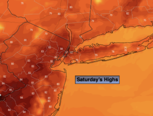
Saturday:
Mostly sunny. Highs in the lower to mid 80s. Northeast to Southeast winds at 5-10mph.
Tonight:
Becoming mostly cloudy and muggy. Scattered showers are likely late. Lows around 70º in the City, the 60s inland. South to Southwest winds at 5-10mph.
Sunday:
Scattered early morning showers giving way to a mix of clouds and sun. Humid. Late day and evening scattered storms are possible. Highs in the mid 80s.
Monday:
Mostly sunny and hot. Highs in the upper 80s to around 90º.
Tuesday:
Partly sunny and hot. Highs around 90º.
Wednesday:
Partly sunny. Very warm. Highs in the upper 80s.